Page 1 of 1
Michigan Lake Huron
Posted: 2022-11-28 11:02:10
by ARG_Afb
Hello everyone! I am glad to announce my new and last map project, as i have to retire from modding due to personal reasons, its gonna be located between pointe aux barques, port austin city and grind stone city, i hope i can complete most of it for christmas as 2023 will be a tough year for me, this year is the last one i have free time to do activities and hobbies, well that being said i will describe it.
-the map is gonna be 8192x8192 meaning 8.1km per 8.1km
-its gonna have real DEM data and a precise PDA (thanks Snake Man)
-the coordinates are these:
https://www.google.com/maps/place/44%C2 ... 82.9299455
Also i have to give a lot of credit to Snake Man, as he was the one that really helped me start in mapping and got a lot of data and imagery, PMC was always there for me when i needed it, Snake, if you ever need help in something, you can count with me as i counted with you, i will try to make some time and help you as you always helped me when i needed you, wish you and everyone the best,
Sincerily
Re: Michigan Lake Huron
Posted: 2022-11-28 13:23:34
by Snake Man
Sad to see you go, you're one of the greatest american farming editing guys in the community. All the work you've done for FS19 and FS22 is awesome.
You linked the center point, I roughly oriented it to center of global mapper user created feature grid marked by X in below screenshot.
USA Michigan Huron 8.1km Design 1.
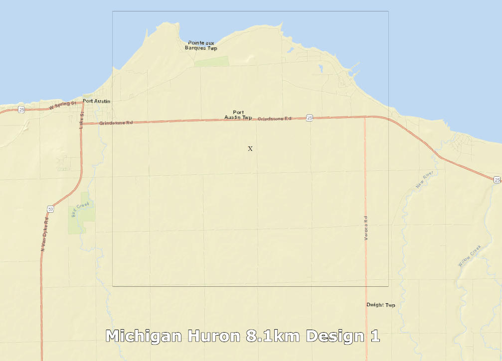
Is the grid in correct position?
How about the road in the south, it gets kind of cut off, do you want coastline to be intact or should we pull the terrain grid to more south to cover the road down there? Remember that it has to be quite bit south to have any useful farm fields south of that road, if the fields are too small then there is really no point shifting that grid location.
Re: Michigan Lake Huron
Posted: 2022-11-28 13:37:05
by ARG_Afb
Hey Snake! Thanks for your words

i really appreciate your help, those coordinates are ok, the coastline makes a great detail and also if the fields are gonna be small so there isnt really any point in making them as you say, so yeah proceed with those coordinates!
Re: Michigan Lake Huron
Posted: 2022-11-28 14:07:44
by Snake Man
Satellite imagery for ArcGIS 17 level download had few big cloud puffs, ugh, luckily US NAIP source was its usual perfect quality.
Heightmap looked oddly smooth, check it out that there is no issues with it.
I have sent you a private message with the link to source files.
Don't forget to post progress updates

Re: Michigan Lake Huron
Posted: 2022-11-28 14:41:02
by ARG_Afb
Thanks Snake! I will download the data maybe at 19:30 UTC
All the progress will be posted here as i want everybody to see how i make maps and hope people find my method useful!
Re: Michigan Lake Huron
Posted: 2022-11-29 00:35:52
by ARG_Afb
first progress made! created the fields layer in the image and painted some fields!
Re: Michigan Lake Huron
Posted: 2022-11-29 00:38:34
by ARG_Afb
Re: Michigan Lake Huron
Posted: 2022-11-29 05:59:22
by Snake Man
Your GIMP pencil opacity is 90, that doesn't paint RGB 255,0,0
Looking good so far, painting fields in GIMP is fun at start, but once you do it 12hrs straight it starts to be a chore heh.
Re: Michigan Lake Huron
Posted: 2022-11-29 11:09:12
by ARG_Afb
Thanks snake for noticing that, yeah, i will correct it, i have been painting the fields for only 30 minutes heh so not a lot but this week i hope i can finish painting them
Re: Michigan Lake Huron
Posted: 2022-11-29 18:25:10
by ARG_Afb
Re: Michigan Lake Huron
Posted: 2022-11-30 04:59:16
by Snake Man
You're doing great progress, keep it up, soon those fields are done
Re: Michigan Lake Huron
Posted: 2022-11-30 11:31:26
by ARG_Afb
Thank you Snake!
Re: Michigan Lake Huron
Posted: 2022-12-01 16:57:51
by ARG_Afb
finished painting some fields and finished the PDA map, images here:
https://imgur.com/a/dPRWGwB
Re: Michigan Lake Huron
Posted: 2022-12-02 01:26:54
by ARG_Afb
finally finished the fields
https://imgur.com/a/FdSg5vo
Re: Michigan Lake Huron
Posted: 2022-12-02 08:11:19
by Snake Man
Congratulations of getting cultivator_density fields painted, its always a big starting point.
Re: Michigan Lake Huron
Posted: 2022-12-03 15:38:21
by ARG_Afb
Re: Michigan Lake Huron
Posted: 2022-12-08 01:58:45
by ARG_Afb
finally finished roads, trees and fields, now we have the basic base to start mapping
https://imgur.com/a/BZOr8sS
Re: Michigan Lake Huron
Posted: 2022-12-08 02:47:30
by Snake Man
Looks good so far, nice work.
Re: Michigan Lake Huron
Posted: 2022-12-08 15:42:33
by ARG_Afb
all the field definitions completed, i dont remember being so fast at mapping lol
https://imgur.com/a/VQ6Xoen
Re: Michigan Lake Huron
Posted: 2022-12-09 15:13:30
by ARG_Afb
Re: Michigan Lake Huron
Posted: 2022-12-09 17:44:04
by Snake Man
You got some decoration objects in as well, good work again.